You are using an out of date browser. It may not display this or other websites correctly.
You should upgrade or use an alternative browser.
You should upgrade or use an alternative browser.
NASA Mission Uses CANON Camera To Map The World's Largest Island
- Thread starter Diko
- Start date

They are flying old prop planes, so maybe they use a D30? The planes are far older than that. They also used DC-8's at one time.
Digging thru the various NASA sites, this is the closest I found to telling about the cameras. Its a 2013 dated article, the photography has been going on for a long time. The cameras apparently date from even earlier.
So, the two cameras could be 5D MK II's. It seems unlikely that the specially modified cameras would be frequently updated.
rating the Digital Mapping System By James Jacobson, Digital Mapping System Data Analyst, NASA Ames Research Center
As a Digital Mapping System (DMS) operator, I have a fairly consistent morning ritual to prepare for a day of flying over the ice. This consistency is necessary for both operational integrity and presence of mind while we are attempting to accomplish our mission. I am often apprehensive at the beginning of a daily mission because I know it is so easy to overlook a small detail that might have a large effect later. All the average person looking down into the P-3 bomb bay would really see is a pair of Canon DSLR cameras pointing down at the ground, unaware of the great care that goes into the preparation.
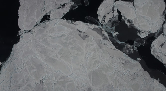 Digital Mapping System image mosaic of Antarctic sea ice. Credit: NASA / DMS Once at the plane, I clean our optical window inside and out with pure ethanol so that there is no residue of dust or grease left behind (a task often made difficult by gusting winds, freezing temperatures and other unforeseen environmental effects). I then clean the cameras and lenses and take a few test frames on the ground to ensure that the cameras are working properly. After that, I set up our GPS receivers to make sure we can capture the position and orientation of the P-3 at many fractions of a second.
Next, I set the camera’s frame rate so we are sure to capture at least 60 to 70 percent overlap from one frame to the next. This changes due to how high or fast we are flying at any given time, I am constantly adjusting and fixing settings during flights, calculating frame rates by hand. Very little of the DMS system is automated for the simple fact that the human eye is often the best tool to determine the correct settings and factors that make for good data collection. I have to use whatever limited time I have at my disposal to get the best results I can, writing down by hand all changes made, as well as environmental conditions outside the plane that might adversely affect our imagery such as clouds, haze, fog or poor sun angle).
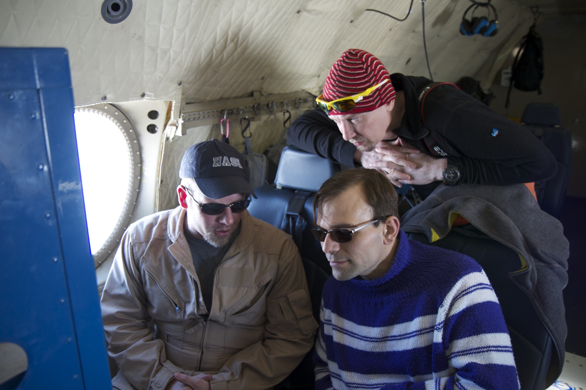 Digital Mapping System operator James Jacobson talks with visiting teachers about the instrument during an IceBridge Arctic campaign flight in 2012. Credit: NASA / Jefferson Beck Because the instrument I operate is, in essence, a pair of very specialized digital cameras, I feel that it often gets overlooked by visitors to our little world within the tin belly of the NASA P-3. I don’t mind, really, as I completely understand the draw that one might have towards the exciting technologies involved in the laser system, the radar arrays, the gravimeter sitting shrouded in the mid-body of the plane, or the magnetometer poised in the P-3’s stinger. But what most people don’t understand is that other than the pilots, I have probably the best view of the world outside the plane while we fly. Through hundreds of thousands of digital photographs I document the world as it passes below us at 250 miles per hour and see it clearly and unobstructed.
Also, I get a view that none of the other instruments get, because as a human being, you can see our data and have and instant and intuitive understanding of what you are looking at, without any need for computers to help you interpret what you are seeing with graphs or charts. They say a picture is worth 1,000 words. What does 15,000 pictures over an 8 hour flight say?
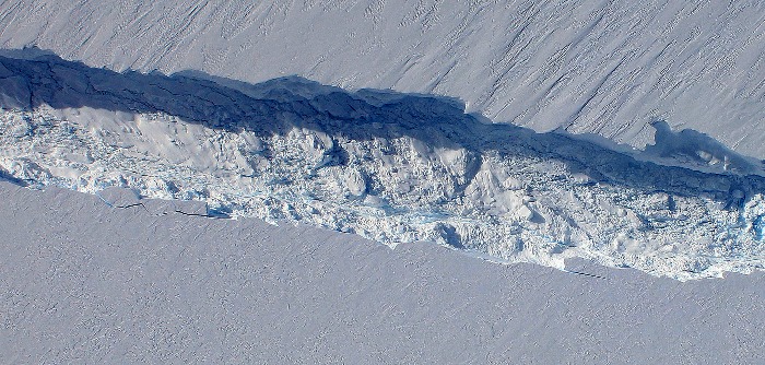 Digital Mapping System image showing the rift in Antarctica’s Pine Island Glacier seen from NASA’s DC-8 during an IceBridge Antarctic campaign flight in 2011. Credit: NASA / DMS As I watch glaciers, mountains, valleys, rivers and ice pass below us in crystal clarity, I am consistently awe-struck by the images that I see. Few people have ever gotten such a pure perspective. Some of the places we go have never been seen by human eyes, and I am both humbled and honored every time we fly by the task and mission we have set before ourselves. It is a fairly daunting mission, with radical scope, and I am proud to be a member of the team responsible for helping to make it happen. Like I said before, the casual observer may think of operating DMS as mundane, but I know for a fact that they don’t see what I see.
https://blogs.nasa.gov/icebridge/2013/12/01/a-clear-view-operating-the-digital-mapping-system/
Digging thru the various NASA sites, this is the closest I found to telling about the cameras. Its a 2013 dated article, the photography has been going on for a long time. The cameras apparently date from even earlier.
So, the two cameras could be 5D MK II's. It seems unlikely that the specially modified cameras would be frequently updated.
rating the Digital Mapping System By James Jacobson, Digital Mapping System Data Analyst, NASA Ames Research Center
As a Digital Mapping System (DMS) operator, I have a fairly consistent morning ritual to prepare for a day of flying over the ice. This consistency is necessary for both operational integrity and presence of mind while we are attempting to accomplish our mission. I am often apprehensive at the beginning of a daily mission because I know it is so easy to overlook a small detail that might have a large effect later. All the average person looking down into the P-3 bomb bay would really see is a pair of Canon DSLR cameras pointing down at the ground, unaware of the great care that goes into the preparation.
Digital Mapping System image mosaic of Antarctic sea ice. Credit: NASA / DMS Once at the plane, I clean our optical window inside and out with pure ethanol so that there is no residue of dust or grease left behind (a task often made difficult by gusting winds, freezing temperatures and other unforeseen environmental effects). I then clean the cameras and lenses and take a few test frames on the ground to ensure that the cameras are working properly. After that, I set up our GPS receivers to make sure we can capture the position and orientation of the P-3 at many fractions of a second.Next, I set the camera’s frame rate so we are sure to capture at least 60 to 70 percent overlap from one frame to the next. This changes due to how high or fast we are flying at any given time, I am constantly adjusting and fixing settings during flights, calculating frame rates by hand. Very little of the DMS system is automated for the simple fact that the human eye is often the best tool to determine the correct settings and factors that make for good data collection. I have to use whatever limited time I have at my disposal to get the best results I can, writing down by hand all changes made, as well as environmental conditions outside the plane that might adversely affect our imagery such as clouds, haze, fog or poor sun angle).
Digital Mapping System operator James Jacobson talks with visiting teachers about the instrument during an IceBridge Arctic campaign flight in 2012. Credit: NASA / Jefferson Beck Because the instrument I operate is, in essence, a pair of very specialized digital cameras, I feel that it often gets overlooked by visitors to our little world within the tin belly of the NASA P-3. I don’t mind, really, as I completely understand the draw that one might have towards the exciting technologies involved in the laser system, the radar arrays, the gravimeter sitting shrouded in the mid-body of the plane, or the magnetometer poised in the P-3’s stinger. But what most people don’t understand is that other than the pilots, I have probably the best view of the world outside the plane while we fly. Through hundreds of thousands of digital photographs I document the world as it passes below us at 250 miles per hour and see it clearly and unobstructed.Also, I get a view that none of the other instruments get, because as a human being, you can see our data and have and instant and intuitive understanding of what you are looking at, without any need for computers to help you interpret what you are seeing with graphs or charts. They say a picture is worth 1,000 words. What does 15,000 pictures over an 8 hour flight say?
Digital Mapping System image showing the rift in Antarctica’s Pine Island Glacier seen from NASA’s DC-8 during an IceBridge Antarctic campaign flight in 2011. Credit: NASA / DMS As I watch glaciers, mountains, valleys, rivers and ice pass below us in crystal clarity, I am consistently awe-struck by the images that I see. Few people have ever gotten such a pure perspective. Some of the places we go have never been seen by human eyes, and I am both humbled and honored every time we fly by the task and mission we have set before ourselves. It is a fairly daunting mission, with radical scope, and I am proud to be a member of the team responsible for helping to make it happen. Like I said before, the casual observer may think of operating DMS as mundane, but I know for a fact that they don’t see what I see.https://blogs.nasa.gov/icebridge/2013/12/01/a-clear-view-operating-the-digital-mapping-system/
Upvote
0
As far as I can tell, they are. According to https://www.nasa.gov/mission_pages/icebridge/instruments/index.html the only camera instrument is the DMS mentioned in your source. The configuration of that instrument is listed at https://asapdata.arc.nasa.gov/dms/reference.html. That page shows a 5D Mark II with either a 28mm or an 85mm lens, depending on operating conditions.Mt Spokane Photography said:So, the two cameras could be 5D MK II's. It seems unlikely that the specially modified cameras would be frequently updated.
Upvote
0
Mt Spokane Photography said:They are flying old prop planes, so maybe they use a D30? The planes are far older than that. They also used DC-8's at one time.
NASA still flies the DC-8. They used it recently over Germany to test biofuels burnt by an A320.
The P-3 is a turboprop plane designed with long endurance (it was designed as a sea surveillance plane) and that can easily operate even from remote airports with limited facilities. It's an excellent platform for such kind of missions. Anyway, to match the plane age they should have used an Exakta Varex II, probably.
Not everybody at NASA is GAS addicted, and needs the latest and the greatest to do good science - it's not "naaah without 20 stops of DR, 100Mpx and 50 fps I don't even take off... and, hey, take away that damned mirror from that camera, it really disturbs me!"
NASA is doomed, of course ;-)
Upvote
0
Upvote
0
Hi Diko.
Thanks for posting an interesting video, though it did cost me ages on utube watching other recommend videos! :")
Thanks to Mt Spokane for linking in another very interesting article.
Cheers, Graham.
Thanks for posting an interesting video, though it did cost me ages on utube watching other recommend videos! :
Thanks to Mt Spokane for linking in another very interesting article.
Cheers, Graham.
Upvote
0
ad said:As far as I can tell, they are. According to https://www.nasa.gov/mission_pages/icebridge/instruments/index.html the only camera instrument is the DMS mentioned in your source. The configuration of that instrument is listed at https://asapdata.arc.nasa.gov/dms/reference.html. That page shows a 5D Mark II with either a 28mm or an 85mm lens, depending on operating conditions.Mt Spokane Photography said:So, the two cameras could be 5D MK II's. It seems unlikely that the specially modified cameras would be frequently updated.
Thanks. That page would not load for me when I tried several times yesterday. The timing of the article suggested that they would use 5D MK II's.
Upvote
0
Since they are remotely controlled, they must be using live view and a remote tethering software like Canon Utilities.
The shutter only opens once and closes once while in live view, so I wonder how many hours they get before a camera fails or needs service.
The shutter only opens once and closes once while in live view, so I wonder how many hours they get before a camera fails or needs service.
Upvote
0
Hi Mt Spokane.
Isn’t it a case of the mirror only flips up once at the start of live view and down once at the end of live view but the shutter closes at the end of each still exposure (they were using stills not video weren’t they?) to allow for reading the sensor and then reopens for live view again, I believe an electronic first shutter is used for the start of the exposure?
It would still be interesting to know the M.T.B.F. of the cameras in this application!
Cheers, Graham.
Mt Spokane Photography said:Since they are remotely controlled, they must be using live view and a remote tethering software like Canon Utilities.
The shutter only opens once and closes once while in live view, so I wonder how many hours they get before a camera fails or needs service.
Upvote
0
Valvebounce said:Hi Mt Spokane.
Isn’t it a case of the mirror only flips up once at the start of live view and down once at the end of live view but the shutter closes at the end of each still exposure (they were using stills not video weren’t they?) to allow for reading the sensor and then reopens for live view again, I believe an electronic first shutter is used for the start of the exposure?
It would still be interesting to know the M.T.B.F. of the cameras in this application!
Cheers, Graham.
Mt Spokane Photography said:Since they are remotely controlled, they must be using live view and a remote tethering software like Canon Utilities.
The shutter only opens once and closes once while in live view, so I wonder how many hours they get before a camera fails or needs service.
You'e right about the shutter.
15,000 images a trip in a extreme high vibration environment would likely result in a short camera life. I'd expect some good shock mounting, but its still difficult on a plane like the P3 that can bounce around pretty severely.
Upvote
0
Geee guys! You are amazing!
Like if I ever need to know more info on someone will put CANON camera in his/her hands and will post a photo of it here
Thanks for the info and the awesome links: Mt Spokane Photography & ad!
Like if I ever need to know more info on someone will put CANON camera in his/her hands and will post a photo of it here
Thanks for the info and the awesome links: Mt Spokane Photography & ad!
Upvote
0
Mt Spokane Photography said:Since they are remotely controlled, they must be using live view and a remote tethering software like Canon Utilities.
The shutter only opens once and closes once while in live view, so I wonder how many hours they get before a camera fails or needs service.
I doubt that. Really. My presumption is that they use a cheap web camera to review the sight of which they took photos and to keep visuals. It much more cost effective. And usually NASA ARE moderate in their spendings. ;-)
Upvote
0
Diko said:Mt Spokane Photography said:Since they are remotely controlled, they must be using live view and a remote tethering software like Canon Utilities.
The shutter only opens once and closes once while in live view, so I wonder how many hours they get before a camera fails or needs service.
I doubt that. Really. My presumption is that they use a cheap web camera to review the sight of which they took photos and to keep visuals. It much more cost effective. And usually NASA ARE moderate in their spendings. ;-)
Except they describe remotely setting the camera adjustments while flying, which means some sort of thethering.
Upvote
0
Similar threads
- Replies
- 7
- Views
- 2K
- Replies
- 7
- Views
- 1K