Travel advice - Northern California and Oregon

Hi all,

I hope this is the right place to post this kind of request, not really Photography Technique but ...

So I am leaving on a US trip in a couple of weeks. The trip is primarily work related, but I'll have some free time in the middle to travel around and hopefully get some nice pictures.

In a nutshell, for the "vacation" part of the trip, I will be driving from El Paso, TX to Portland, OR. I have 10 days to complete this whole trip (and because of the work-related constraints, I can't stretch that for even just one more day, unfortunately). So while that's relatively comfortable, there will still be quite a bit of driving every day. I'm OK with that, obviously, but that's something to keep in mind.

I'm also pretty set on my itinerary for the first half of the trip. There are a number of places that I've wanted to visit for a long time, and never had a chance until now, even when I used to live in the US. So easy itinerary to begin with: Grand Canyon, Las Vegas, Death Valley.

From there, I'm a lot more uncertain about which way to choose. I am much less familiar with interesting locations in California (I've only ever been to the LA and San Diego area), and especially Oregon, which I know nothing about. There seems to be no shortage of spectacular scenery in that region, but I'll have only 4 days to go from Death Valley to Portland, so really not much time to circle around.

So this is where I could use some suggestions. Any recommendation as to which route I should choose? (Roughly speaking of course, I'm not asking for a detailed itinerary here.) Keeping in mind that (1) as mentioned, I'll have to drive quite a bit every day, so time is somewhat limited. Quick photo stops along the way are OK, but as much as I'd love to spend a few days in Yosemite, for example, that's just not a possibility here. And (2) it will be mid-November, so (I'm assuming) there might be some weather issues at play here.

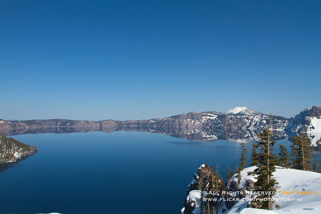
The way I see it, I have essentially two options: going through Central Oregon, via Crater Lake, Bend, and the Columbia River Gorge; or hit the coast early, hit Redwood, and drive up the coast. Perhaps having options is good, because the weather might end up forcing my hand one way or the other ... But otherwise, any suggestions would be greatly appreciated. Is Crater Lake (and surrounding areas) still worth it mid-November? And how's the drive up the coast on 101? (It's already the longer way, if it's also the slower one, I might end up spending 100% of my time driving.) Am I overlooking other options, in Eastern Oregon for example?

TLDR; If you had 4 days to drive from Death Valley to Portland, OR, looking for scenic roads and photogenic spots along the road, which way would you go?

Thanks in advance :)
 
Allow yourself 2 days driving time between El Paso, Texas and Portland not counting stops or side trips.

You essentially have two choices and you may or may not be able to see everything on your itinerary:

El Paso to Portland via I-15/I-84, or El Paso to Portland via I-10/I-5.

The I-15/I-84 will take you through Albuquerque New Mexico, Utah and Idaho. The second route I-10/I-15 will take you from El Paso thru Arizona (Grand Canyon), and California up to Portland.


Hwy. 101 is a good route depending on time of day, especially coming up thru Los Angeles. Hwy. 1 will take you along the coast thru Santa Monica, Ventura, Santa Barbara, Big Sur, Carmel, Monterey, etc. It will take longer longer taking the coast route but its beautiful. I suggest checking with the National Weather Service. Although we're having a drought here in California, you could run into heavy fog -- going thru Utah, you might encounter snow.
 

Attachments

  • ElPaso2Portland.png
    ElPaso2Portland.png
    778.5 KB · Views: 218
Upvote 0
10 days is a nice stretch of time to make that trip.

I've travelled around that area and here's my highlights list, in order leaving TX and heading to OR, with a few twists and turns. I've taken a few liberties at the start of your trip that you didn't have in, basically a north / south jaunt on your way to Grand Canyon.

- White Sands National Monument, NM (good sunset spot)
- Carlsbad Caverns, NM
- Monument Valley, 4 corners area - get a guided sunrise tour with a local guide, it's so worth it!
- Antelope Canyon, Page, AZ - again, guided tour required, sign up for a photographers tour if your timing works but the regular tours give you time to set up a tripod a few times. Check out horseshoe bend while you're in the area.
- Grand Canyon
- Las Vegas
- Death Valley
- Yosemite - can be done in a day with an early start, at least you'll get to see the highlight spots. Of course, a week is nicer!
- San Francisco and Route 101 if you have time left to take the longer road trip

It's an absolutely amazing part of the world to take a trip through, enjoy!!! And make sure you have a decent tripod and remote, but you already knew that. :)
 
Upvote 0
In Oregon you can't go wrong on either the central or coast route. Personally I would choose the central route just because the weather will be slightly more predictable and there's always the odds of getting snow.

I'm a native Oregonian and have been to most of the well known sites along these routes, so let me know if you want some more details on the routes you have as options. Both routes will provide you with the option to cut back to I-5 if you need to get back to Portland quickly.
 
Upvote 0

Bruce Photography

Landscapes, 5DX,7D,60D,EOSM,D800/E,D810,D7100
Feb 15, 2011
216
0
Fort Bragg, CA
I live in Fort Bragg CA which is less than 200 miles north of San Francisco. I really don't know which way I would go from Texas but it seems a shame to miss Big Sur south of San Francisco. However for me, I decided to move from San Diego to here in Fort Bragg because of the rugged coastline, many rivers, redwoods, active ocean fishing, and moderate temperature. It is now green here because we've had some rain - it is starting to look like Ireland. From San Francisco, go up 101 until you get south of Santa Rosa and turn west to get to Bodega Bay and then follow Hwy 1 all the way to Leggit where it joins 101 again. This Hwy 1 loop has some of the most diverse seascapes that I've seen and will prepare you for the coast route through Oregon.
 
Upvote 0
I'd go an entirely different route -- First, head through Death Valley through Pahrump, and go north -- at the north end, go out to Hwy 395 and go north. Stay on Hwy 395 to either Hwy 120 or Hwy 4 west and head over the mountains.

Take Hwy 49 north and hit Hwy 12 west ... head for San Francisco, but then hit I-5 and pass around SF, and then find your way to Hwy 1 along the coast. That's thru the Redwoods and along the Oregon Coast ...

As an alternative, stay on hwy 395 all the way north, and pass into Oregon on the east -- then travel the roads across Oregon to the west coast and then north.

Hwy 395 is much nicer than Hwy 1 or 101 below SF -- way too much traffic and a lot of the roads are damaged and in disrepair. Hwy 395 is amazing and scenic -- you can trip in and out of the mountains on a few side roads as well. The Oregon coast is equally as scenic,o=if not more scenic as the California coast -- and missing the traffic is a nicer way to travel.

If you're driving and planning on Motels -- buy a small tent and cooler -- stay in a campground once or twice along Oregon coast (they are open all year) -- they are some of the finest campgrounds in the USA.
 
Upvote 0
slclick said:
I just returned from Oregon (Eugene area) and I took the Sigma Art 35 and 24-105. What did I miss taking? Creative lenses such as my Lensbaby's and a Macro kit. Just so much green, life, flora and decay in the woods there!

I don't hang out around Eugene too much, but Dexter lake is nice to float on and the McKenzie river is gorgeous. If you're ever there again, I would recommend driving along hwy 126 from Eugene to Clear Lake where the McKenzie River starts. Along the way you would see Sahalie and Koosah falls while following the river. You should also stop by the "Blue Pool" also known as Tamolich pool. And of course your destination would be Clear Lake, which is amazing. No motorized boats so the water is usually like a mirror. Underwater visibility is usually around 100 ft, so it really does earn it's name.
 
Upvote 0
As Monkey just noted, 395N is a nice route to travel and really the only practical choice from Death Valley. Where you turn west would depend on if you have any destinations of interest before you reach Tahoe.

You can go west into Yosemite to Toulumnee Valley. That's less than 30 minutes off 395, so you could run up, take pics, and head back down to 395 again. There is a granite dome (Sentinel?) next to the Meadow road that you can hike and get good overlooks. If you want to do a more substantial hike, Mt Dana is right at the park entrance and is the second tallest peak in Yosemite with a great view of the Meadow and of Mono Lake below.

Mono Lake itself could be a stop, though better if you get in a kayak. Also, not sure what the water level is like due to the drought.

If you're a Western fan, a lot of movies were filmed at Lone Pine and the Alabama Hills, fairly near to Death Valley.

Just north of Yosemite and the 120 route west is the Sonora pass (108) which is a bit taller, less trafficked, and also has good forest and granite mountain vistas. It tends to be open slightly longer than 120, but for both, once the winter snows come they may be closed until spring.

And then further north is Lake Tahoe and a lot of hikeable trails, waterfalls, overlooks. If you keep heading north past Reno, you can then go west towards Mount Lassen->Redding and then go north on I-5 for time.

If you ended up staying at San Francisco as a stop, then you have Muir Woods and Point Reyes. But in the interests of getting up to Oregon, you then need to backtrack east to get on I-5, so perhaps the wrong idea for a short schedule. Same with Big Sur which is fantastic but better left for another time.
 
Upvote 0
The OP only has 10 driving days. Although very scenic, Hwy. 395 will take longer and this time of year, weather and road conditions could be a factor, especially around Mojave, Bishop, Bridgeport, and as you near Yosemite and Lassen. On my way into work this morning, there was heavy fog in and around Sacramento. Its burned off now but I wouldn't want to be driving on unfamiliar roads in the fog.


monkey44 said:
I'd go an entirely different route -- First, head through Death Valley through Pahrump, and go north -- at the north end, go out to Hwy 395 and go north. Stay on Hwy 395 to either Hwy 120 or Hwy 4 west and head over the mountains.

Take Hwy 49 north and hit Hwy 12 west ... head for San Francisco, but then hit I-5 and pass around SF, and then find your way to Hwy 1 along the coast. That's thru the Redwoods and along the Oregon Coast ...

As an alternative, stay on hwy 395 all the way north, and pass into Oregon on the east -- then travel the roads across Oregon to the west coast and then north.

Hwy 395 is much nicer than Hwy 1 or 101 below SF -- way too much traffic and a lot of the roads are damaged and in disrepair. Hwy 395 is amazing and scenic -- you can trip in and out of the mountains on a few side roads as well. The Oregon coast is equally as scenic,o=if not more scenic as the California coast -- and missing the traffic is a nicer way to travel.

If you're driving and planning on Motels -- buy a small tent and cooler -- stay in a campground once or twice along Oregon coast (they are open all year) -- they are some of the finest campgrounds in the USA.
 
Upvote 0
Personally, if it were me, I'd go thru Arizona up thru California to Portland. If you take Hwy. 101, you can switch back and forth between Hwy. 101 and PCH (Hwy. 1)., As well as I-5 (boring drive but you'll make up time).

There will be a lot to see from Santa Barbara on up. There's the Santa Barbara Mission, Hearst Castle in San Simeon, Morro Bay, Cambria, Paso Robles, Big Sur, Keyhole Rock at Pfeiffer Beach, Monterey & Carmel just to name a few places. Up towards San Fran, there's Point Reyes, Bowling Ball beach, Mt. Tamalpais, Marin County and other sites.

I'm heading down to Big Sur in about a week. Can't wait.
 
Upvote 0
Is this a round trip (El Paso to Portland and back), or is it one-way?

If round trip, good luck having much time to see anything along the way in only 10 days. Using Google's recommended route from El Paso to Portland, it's still about 25 hours of driving, without stops along the way. For a return trip through California using Google's recommended route, it's another 26 hours, without stops, for a combined 51 hours of driving. That's still 5 hours of driving every day, without any stops.

If one-way, you've got a bit more time to spend at each place you choose to stop, but the route you choose will be more important. I'd rather spend a meaningful amount of time at a few neat places than rush through as many as I can hit.
 
Upvote 0
If you had a shload more time, I'd consider a loop like this:

1. White Sands National Monument (Up I-10 to Las Cruces, then east on 70)
2. Grand Canyon (West on I-10 to Phoenix, then I-17 to Flagstaff, then HWY 180?)
3. Antelope Canyon Photo Tour (HWY 89 to HWY 98)
4. Lake Powell (HWY 89)
5. Zion National Park (HWY 89 to HWY 9)
6. Bryce Canyon (Back across HWY 9 to HWY 89, then HWY 63)
7. Salt Lake City and Temple Square (Go West to I-15, then head North)
8. Park City (East on I-80)
9. Columbia River Gorge (I-80 West to I-15 North, then I-84 West*)
10. Portland (You made it!)
11. Oregon Coast (Perhaps HWY 99/18 to Lincoln City, then down HWY 101)
12. Redwood National and State Parks, Fern Canyon, etc.
13. Agate Beach at Patricks Point State Park? Lots of seals at Patricks Point...
14. San Francisco
15. Yosemite (Whatever route Google says is best :) )
16. Death Valley
17. Las Vegas
16. Back to El Paso...

According to Google, hitting everything on this list would require about 70 hours of driving. Yikes. That would be 7 hours every day, without stops, so that definitely qualifies as a whirlwind tour (although only 2 hours a day more than Google's recommended direct routes). Better to have 30 days for this one...

* If you can hit Dead Man's Pass at sunrise or sunset, all the better! Not many other photo ops between Salt Lake City and the Gorge. :p
 
Upvote 0

drmikeinpdx

Celebrating 20 years of model photography!
A Note From Portland

I am writing this from Rainy, Stormy, Portland! We actually had a tornado or two and torrential rain in the area yesterday.

November is a bad time to visit Oregon! We don't even have much Fall foliage to look at. If it were me I would spend as little time as possible here and spend most of your time visiting the Grand Canyon, Arches, and other areas in the warmer and dryer part of the country. You will certainly get A LOT MORE nice scenic photos to take home.

If you happen to love cold, rainy weather, then this advice might not apply to you. This time of year, most Portlanders hang out in the brewpubs and coffee shops or at Powell's Books. It's a tough time of year to do any kind of scenic photography. A waterproof camera might be helpful. LOL

Oh, and find the web sites for the various state's highway departments. Bookmark them on your mobile device. They will have information on the road conditions in the mountain passes you will be going through. November is hard to predict, the roads could just be wet or they could be covered with dirty snow.

Also remember that the days are short. Driving 14 hours may not be too bad in daylight, but when most of it is in the dark, your fatigue level may become excessive. Certainly your speed will have to be less. I would estimate four days from El Paso to Portland myself.
 
Upvote 0
Wow, thanks all, that's a lot of very useful answers. I'll take some time to look more carefully at all your suggestions, but for a quick answer to some of the questions:

* the trip is one way, thankfully. So that leaves me at least *some* time out of the car :D
* I'm already more or less prioritizing the Southern part of the trip, spending more time down there, whereas I'll have to drive a bit more per day on those last days towards Oregon.
* I actually happen to like cold and rainy weather, call me crazy ^^ Although this may end up swaying me towards the coastal route ... there's little I like more than the beach in winter (although it'll be a first for the Pacific Coast)

Again, thanks all for your answers, much appreciated !
 
Upvote 0
Whew! One-way definitely makes it a bit easier to fit things in. If that's the case, unless you really want to see the sites in Utah, I'd do Grand Canyon, Las Vegas, Death Valley, Yosemite, San Francisco, Redwoods, then on up 101 until Lincoln City (or until you're tired of the coast), then east over to Portland. Once in drizzly Portland, Powell's books, as mentioned, is a great place to chill -- if you like reading. :)

I've actually always loved the coast during the nasty weather. The clouds, mist, rocky cliffs -- can make for some great photos. Get the sun to peak through those clouds once or twice during sunset, and you've got some dramatic skies just begging to be captured. I'd bring an ND filter and stout tripod for some silky water shots on those rocky shores.

Should be a great trip! Drive safely, and enjoy the journey as much as the various destinations...

PS: If you like split-pea soup, be sure to stop at Andersen's in Buellton, CA (right on 101, about 40 minutes north of Santa Barbara). Could really hit the spot if it's a bit nippy outside. :p
 
Upvote 0
If you're doing the Oregon Coast route, I would suggest continuing on the coast further than just Lincoln City. You'd be missing out on the three capes and if it's dry climbing to the top of the dune at Cape Kiwanda is worth it. Also further north near Ecola State Park is Smuggler's Cove, which is just a quarter mile walk from hwy 101.

Along the Oregon coast definitely stop at Devil's Punchbowl, but other than that many of the state parks are nice.
 
Upvote 0