I know that the GP-E2 is available for the newer Canon bodies. I notice that there are a lot of third party options for Nikon bodies. Anyone know of inexpensive way to get gps tagging without the 250$ price tag? I have found solutions for nikon costing 40$ that looks very similar to what the gp-e2 achieves. I have tried EyeFi and I think it is a waste of time. (too small capacity, and it must be uploaded to eyefi and besides it not really GPS, it wont work where there aren't any hotspots). What are my options of i want GPS tagging in Exif, and lightroom comaptible?
You are using an out of date browser. It may not display this or other websites correctly.
You should upgrade or use an alternative browser.
You should upgrade or use an alternative browser.
Canon GPS Options
- Thread starter Wilmark
- Start date
- Status
- Not open for further replies.
Pretty much any GPS unit produces a log that can be downloaded to your computer and synched to your photos using the time stamp. This requires that your camera have the correct time, which can be synched to a pc with Canon Utility such that its accurate to the second.
Some cell phones have this capability, and GPS data loggers are cheap.
Some cell phones have this capability, and GPS data loggers are cheap.
Upvote
0
Unless you have either a 1DX or a 5DIII the GP-E2 won't do anything for you that a third party GPS logger would not do for a lot less money. Although if you shoot with one of these two cameras, there are some features that make the GP-E2 an option to consider (hot shoe connectivity, automatic time synchronization, addition of compass data to the GPS data).
Upvote
0
I use a standalone GPS logger (not a nav device, not a smartphone) for this purpose.
My model is a Holux M-1000C (not really a recommendation but I can't complain -- reasonably priced, 20+ hours of logging on one battery, spare batteries readily available as it uses one of the popular Nokia phone batteries).
There's plenty of options, just choose whatever suits you: http://www.bt747.org/compatible_gps
I download the track and convert it to GPX using http://www.bt747.org/ -- requires getting used to as it has its quirks but does the job.
I then geotag the photos using Exiftool, http://www.sno.phy.queensu.ca/~phil/exiftool/. It cross references the dates/ times in the EXIF data in CR2 and JPG with the GPX file and updates the EXIF with location.
Alternatively, you can use Lightroom for this task (4.0+), it will also geocode (provide address for lat/long coordinates) but it won't update the actual CR2's though, I believe.
The benefits of this method are that you can geotag photos from multiple cams this way and that you can use the track for other purposes. FWIW, you can get the logger to log things like altitude and velocity which make a nice addition to photos shot from airplanes -- not sure if Canon's GPS module does this.
Upvote
0
There are iPhone apps for it that are dirt cheap, if you have an iPhone. Just make sure the times match on the camera and the phone, then after you upload your pics the program somehow links up with the pics by time and ads the location data.
Upvote
0
I'm using the GP-E2. I like it as there are no extra steps. The photos coming off the camera are already tagged, whatever you end up doing with them. The disadvantage is that it is bulky (but not heavy) so it has to come off the camera to go in my bag (Lowepro Passport Sling), therefore needs to be fitted when I next shoot. It can be used as a logger, but there are cheaper solutions for that role. I've had no issues with acuracy and it is speedy getting a satellite lock.
Upvote
0
It sounds like the canon solution is the most painless. I am wondering if my Galax Nex phone can work for this (Via an android ap, and synced time). However i find that i often don't get sat location (in Google Maps) with it. But is there a Non canon solution that will effortlessly tag the files even if its in software and done in say one or two steps after a days shoot. What about loss of the hotshot. If you use a flash, do you loose that ability to tag with the GPE2? I also read that there are a lot of complaints about the size. I am wondering if we wont see third party implementations of the GPE2 soon. The GPE2 doesn't see overly overpriced by canon standards. Thanks for all the comments!
Upvote
0
P
pharp
Guest
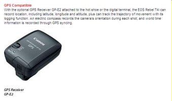
Well ... The 1DX uses the GP-E1. In addition to the 5Diii and 7d firm2 [limited functionality], the GP-E2 will also work with the new T4i [see attached 'snap' from Canon's website] and upcoming M [mirrorless] http://www.imaging-resource.com/PRODS/canon-eos-m/canon-eos-mA.HTM with complete functionality, like compass direction. I'll assume this will be Canon's new standard GPS for most upcoming models. So does this mean some 3rd party will make a cheaper version someday? - probably so. How about a wireless version?stefsan said:Unless you have either a 1DX or a 5DIII the GP-E2 won't do anything for you that a third party GPS logger would not do for a lot less money. Although if you shoot with one of these two cameras, there are some features that make the GP-E2 an option to consider (hot shoe connectivity, automatic time synchronization, addition of compass data to the GPS data).
Attachments
Upvote
0
I have a GP-E2 on order for my 5D3 and 7D. Expensive but over the life of the cameras I have I find it will be worth it.
Upvote
0
I wish they made a GP-E2 for the 5Dm2. It is the one new thing I really like about the 5Dm3.
Maybe there is some other way, but the only way I know of is to get the WFT-e4a and a USB GPS unit. You can get a small bluetooth USB thing and have a wireless bluetooth GPS device too.
Maybe there is some other way, but the only way I know of is to get the WFT-e4a and a USB GPS unit. You can get a small bluetooth USB thing and have a wireless bluetooth GPS device too.
Upvote
0
L
Loswr
Guest
pharp said:Well ... The 1DX uses the GP-E1.
Well...the 1D X can use either the GP-E1 or the GP-E2. But GP-E1 can only be used with the 1D X. The GP-E1 does not offer the logging function that the GP-E2 does, but it's smaller and more robustly constructed (better sealing), allows simultaneous use of a hotshoe-mounted flash (without needing to resort to the USB connection), and it's powered by the camera battery rather than an internal AA battery.
Upvote
0
S
sparkle999
Guest
Wilmark said:What are my options of i want GPS tagging in Exif, and lightroom comaptible?
Hi there, first post from me here on these forums but hopefully this may help you. Take a look at ImageIngester or Ingestamatic, both apps are designed to automate the process of bringing new images into your photography catalogue from your memory card(s). There are facilities to merge in the track log from whatever GPS device you have, and stamp that automatically into your metadata for your image. Also helps build your lightroom or EM2 catalogue sets automatically, stamp in copyright data, covers off backing up, DNG conversion and flexibly renaming your image files.
Here's a link comparing both apps, both by the same guy: http://basepath.com/site/ingestamatic-comparison.php
All the best,
sp.
Upvote
0
P
pharp
Guest
neuroanatomist said:pharp said:Well ... The 1DX uses the GP-E1.
Well...the 1D X can use either the GP-E1 or the GP-E2. But GP-E1 can only be used with the 1D X. The GP-E1 does not offer the logging function that the GP-E2 does, but it's smaller and more robustly constructed (better sealing), allows simultaneous use of a hotshoe-mounted flash (without needing to resort to the USB connection), and it's powered by the camera battery rather than an internal AA battery.
I stand corrected. I do prefer having a separate battery for the GPS - they tend to be battery hogs. I really don't care about the logging function - will still carry and use my Garmin for those functions [e.g. waypoints, routing, etc.]. I'm not thrilled with the shoe mount though. They really need to come up an alternative mounting method, especially one that doesn't require the inelegant cable connection. It's a start though - I'm just glad Canon has finally seen the light. I know alot of folks have no value in this, but I for one am thrilled [maybe overstated].
Upvote
0
L
Loswr
Guest
pharp said:I'm not thrilled with the shoe mount. They really need to come up an alternative mounting method, especially one that doesn't require the inelegant cable connection. It's a start though - I'm just glad Canon has finally seen the light. I know alot of folks have no value in this, but I for one am thrilled [maybe overstated].
I may pick one up at some point...I agree that the hotshoe mount is not optimal, and also that an internal battery is a plus. The GP-E1 does use an alternative mounting method:

...but the downside is that it conflicts with the RRS L-bracket. So, I'm still undecided which one I'll get. Either way, it's not high on my list of priorities.
Upvote
0
L
Loswr
Guest
pharp said:Agreed, it would be better mounted on the front. I guess the alternative to the RRS L plate would be an universal [adjustable] one like by acratech.
It's not as bad as it sounds - I really like the RRS design. It's their first one (for a Canon dSLR) that's modular - the L part and the base plate can be separated, meaning if the side L isn't needed, it cam be removed, and it's also possible to configure the L further from the side of the camera (allowing room for the GP-E1). But the big gap with the GP-E1 at the top is not really an elegant solution.
One other really nice thing about the RRS plate - the hex wrench needed to make the adjustments actually stores inside the place, held in place magnetically.
Upvote
0
- Status
- Not open for further replies.
Similar threads
- Replies
- 449
- Views
- 186K
- Replies
- 17
- Views
- 13K